Difference between revisions of "WorldSpace"
Jump to navigation
Jump to search
imported>Qazaaq |
imported>Qazaaq |
||
| Line 15: | Line 15: | ||
*'''Parent Worldspace:''' If you select NONE, the worldspace will have its own, editable landscape. Otherwise, this worldspace will use the landscape of its parent. | *'''Parent Worldspace:''' If you select NONE, the worldspace will have its own, editable landscape. Otherwise, this worldspace will use the landscape of its parent. | ||
*'''Use Sky Cell:''' Uses the sky cell of the parent worldspace. This will allow flying creatures to enter the worldspace from the parent space. | *'''Use Sky Cell:''' Uses the sky cell of the parent worldspace. This will allow flying creatures to enter the worldspace from the parent space. | ||
*'''Output Cell Ref Counts:''' | *'''Output Cell Ref Counts:''' Outputs information to a [[Text File#TSB|TSB Text File]]. The information will provide the number of [[Reference]]s within each [[Cell]] associated with this [[WorldSpace]]. This may be useful for analysis or debugging. | ||
*'''Sharable Data''' | *'''Sharable Data:''' The following fields are only available if this object has a ''Parent Worldspace''. | ||
**'''Use LOD Data:''' | **'''Use LOD Data:''' If checked, LOD Data is enabled for this [[WorldSpace]]. | ||
***'''LOD Water Height:''' | ***'''LOD Water Height:''' Elevation that LOD water appears. | ||
***'''LOD Water Type:''' The [[WaterType]] to use. | ***'''LOD Water Type:''' The [[WaterType]] to use. | ||
**'''Use Water Data:''' | **'''Use Water Data:''' If checked, specified IS data will be enabled for this [[WorldSpace]]. | ||
***'''Water:''' The [[WaterType]] to use. | ***'''Water:''' The [[WaterType]] to use. | ||
**'''Use Climate Data:''' | **'''Use Climate Data:''' If checked, the specified climate data will be enabled for this [[WorldSpace]]. | ||
***'''Climate:''' The [[Climate]] to use. | ***'''Climate:''' The [[Climate]] to use. | ||
**'''Use Map Data:''' | **'''Use Map Data:''' The world map [[Texture File]] for this [[WorldSpace]]. | ||
***'''Map Image:''' | ***'''Map Image:''' Select the DDS file to use. | ||
***'''Usable Dimensions:''' | ***'''Usable Dimensions:''' Set the limits of the playable area of this [[WorldSpace]]. The area is defined from the ''North West'' corner, to ''South East'' corner. | ||
****'''X:''' | ****'''X:''' The ''North West'' corner diminsion. | ||
****'''Y:''' | ****'''Y:''' The ''South East'' corner diminsion. | ||
***'''Cell Coordinates:''' | ***'''Cell Coordinates:''' | ||
****'''NW Cell X:''' | ****'''NW Cell X:''' | ||
| Line 34: | Line 34: | ||
****'''SE Cell X:''' | ****'''SE Cell X:''' | ||
****'''SE Cell Y:''' | ****'''SE Cell Y:''' | ||
***'''Use Land Data:''' | ***'''Use Land Data:''' If checked, land data will be enabled for this [[WorldSpace]]. | ||
****'''Default Land Height:''' | ****'''Default Land Height:''' Specifies land elevation value. | ||
****'''Default Water Height:''' | ****'''Default Water Height:''' Specifies default water elevation value. | ||
**'''Distant LOD Multiplier:''' | **'''Distant LOD Multiplier:''' | ||
Revision as of 12:00, 15 December 2018
Type: WRLD
Papyrus: WorldSpace Script
A WorldSpace is simply an entire world, with its own landscape, sky and weather.
All exterior cells belong to a worldspace.
Most of the exterior is in the Commonwealth worldspace, but there are other worldspaces used in Fallout 4.
Worldspaces can share landscape with a Parent worldspace or they can use an entirely different landscape.
WorldSpace Objects can be viewed and edited from the main toolbar by navigating to World -> World Spaces....
Editor Dialog
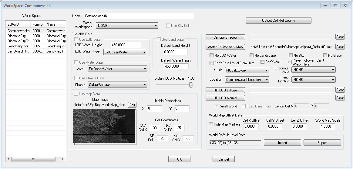
- ID: The ID, also referred to as Editor ID, is used by the Creation Kit to uniquely identify this record within a Data File. The Editor ID is displayed on the World Space list.
- Name: This object's name as it will appear within user interface menus or when the player looks at it.
- Parent Worldspace: If you select NONE, the worldspace will have its own, editable landscape. Otherwise, this worldspace will use the landscape of its parent.
- Use Sky Cell: Uses the sky cell of the parent worldspace. This will allow flying creatures to enter the worldspace from the parent space.
- Output Cell Ref Counts: Outputs information to a TSB Text File. The information will provide the number of References within each Cell associated with this WorldSpace. This may be useful for analysis or debugging.
- Sharable Data: The following fields are only available if this object has a Parent Worldspace.
- Use LOD Data: If checked, LOD Data is enabled for this WorldSpace.
- LOD Water Height: Elevation that LOD water appears.
- LOD Water Type: The WaterType to use.
- Use Water Data: If checked, specified IS data will be enabled for this WorldSpace.
- Water: The WaterType to use.
- Use Climate Data: If checked, the specified climate data will be enabled for this WorldSpace.
- Climate: The Climate to use.
- Use Map Data: The world map Texture File for this WorldSpace.
- Map Image: Select the DDS file to use.
- Usable Dimensions: Set the limits of the playable area of this WorldSpace. The area is defined from the North West corner, to South East corner.
- X: The North West corner diminsion.
- Y: The South East corner diminsion.
- Cell Coordinates:
- NW Cell X:
- NW Cell Y:
- SE Cell X:
- SE Cell Y:
- Use Land Data: If checked, land data will be enabled for this WorldSpace.
- Default Land Height: Specifies land elevation value.
- Default Water Height: Specifies default water elevation value.
- Distant LOD Multiplier:
- Use LOD Data: If checked, LOD Data is enabled for this WorldSpace.
Context Menu
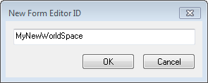
- New: Creates a new WorldSpace. Enter an ID for this new Form.
- Duplicate: Duplicates the selected WorldSpace.
- Delete: Marks the selected WorldSpace for deletion. See also the Data Window.

